
Cybersecurity Training Course in Kenya
June 25, 2024
Best Photography School – Training Course & Classes in Kenya
June 25, 2024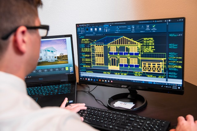
Civil 3D Training courses Classes in Kenya
Introduction to Civil 3D Training: Learn the Basics of Civil 3D Technology Outline: a. Overview of Civil 3D technology Civil 3D is a civil engineering design and documentation software used by surveyors, civil engineers, and drafters to create 3D models of civil engineering projects such as roadways, bridges, and drainage systems.
The software is designed to be used in the design process to make sure the project meets all requirements, that the designs are accurate, and that the end product is aesthetically pleasing. Civil 3D includes powerful tools for creating, editing, and analyzing a variety of civil engineering structures in 3D.
It also includes a number of tools for creating annotations, labels, and other data about the project. Civil 3D is used by many organizations, including government agencies, engineering firms, and construction companies.
What is Civil 3D Used For?
Civil 3D is used for a variety of civil engineering projects. It can be used to design roads and highways, bridges, drainage systems, utility systems, and more. It can also be used to create renderings of proposed projects, which can be used to present the project to stakeholders and other interested parties. Civil 3D can also be used to manage construction documents, such as drawings, plans, and specifications. It can also be used to create plans for surveying and other activities
Benefits of Civil 3D in Civil Engineering Projects
- Improved Design Accuracy: Civil 3D helps civil engineers achieve more accurate designs by providing tools that allow them to visualize and modify project components in 3D.
- Automated Design: Civil 3D automates many of the tedious design tasks that are required in civil engineering projects. This allows engineers to focus more on the details of the project and less on the mundane tasks.
- 3D Modeling: Civil 3D enables engineers to generate 3D models of their projects. This allows them to gain a better understanding of the project and identify potential problems before they become costly issues.
- Reduced Design Time: Civil 3D streamlines the design process by providing tools to quickly generate designs and make changes. This reduces the amount of time it takes to complete a project, resulting in faster project completion times.
- Improved Collaboration: Civil 3D makes it easy for engineers to collaborate with other stakeholders on projects. This allows engineers to quickly share design changes and updates with other team members.
- Cost-Effective: Civil 3D provides civil engineers with a cost-effective platform to complete their design projects. It reduces the need for manual labor and the associated costs.
Basic components of Civil 3D software
- AutoCAD: AutoCAD is a powerful 2D and 3D design program that is used to create and modify drawings.
- Point cloud: Point clouds are collections of data points in a three-dimensional space that are used to represent the surface of an object.
- Survey data: Survey data is information collected from the field that is used to create drawings and models.
- Alignments: Alignments are lines in Civil 3D that define the path of a roadway or other linear feature.
- Profiles: Profiles are cross sections of points along a line that define the elevation of a roadway or other feature.
- Corridors: Corridors are surfaces created by combining alignments and profiles to represent the final shape of a roadway or other linear feature.
- Parcels: Parcels define the boundaries of parcels of land.
- Grading: Grading is used to create surfaces that are level, sloped or contoured.
- Assemblies: Assemblies are collections of objects that can be used to quickly create complex features such as roads, curbs, and gutters.
Janeson Institute Kenya offers the best in Civil 3D Training courses Classes in Kenya.
Visit our Website https://janeson.institute and feel free to reach us at +254729454570


